Here's the report of my recent trip to White Rim Trail at Canyonlands National Park for those interested in road conditions on this epic 100-mile adventure:
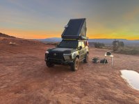
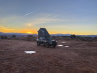
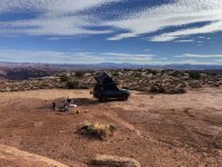
I was able to secure White Crack campsite for two nights. White Crack is the most difficult campsite to obtain since it is regarded as the best one due to its secluded location and scenery. All other campsites are located next to the road and generally don't offer much visual appeal.
I was able to secure White Crack campsite for two nights. White Crack is the most difficult campsite to obtain since it is regarded as the best one due to its secluded location and scenery. All other campsites are located next to the road and generally don't offer much visual appeal.
- Direction of travel: Counter-Clockwise starting at Mineral Bottom Trail
- First obstacle is Upheaval Wash going this direction. It was muddy but otherwise dry when I arrived but trail can become impassable if the water level is too high.
- Second obstacle is the ascent and descent of Hardscrabble Hill. Hardscrabble is difficult at this time due to exposed rock ledges, muddy, and lots of rocks to traverse. Would recommend 4Lo and center diff lock on the ascent and M1 on the descent. Both ascent and descent are equally difficult. My wife closed her eyes and strapped down for the ride.
- Third obstacle is Murphy Hogback. No rock ledges here just big rocks to traverse. The ascent ends at Murphy Hogback campsite. The final climb to the campsite scales what seemed like a vertical wall so I put the vehicle in 4Lo and prayed no one was on the other side. If you are going clockwise I would recommend going very slow as you approach Murphy C so the descent wouldn't be so terrifying. The descent of Murphy can get extremely off camber so be careful and try not to stop if your car leans.
- A lifted GX is preferred at this time due to current deteriorating conditions. Good skids would be nice as well if tire placement goes wrong.
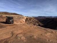
- No other difficult obstacles exist as you make your way to the midpoint at White Crack. Beyond White Crack there will be small hills to traverse but nothing of note. After the Airport campsites there is a section full of rocks before reaching Musselman Arch. One final hill ascent then your choice to exit via Shafer switchbacks or take Potash Rd to Moab. Shafer is more fun.
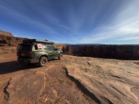
- Points of interest: Black Crack, a geological fissue, located near Candlestick campsite. If going counter the fissure is located about a mile or two east of Candlestick on the south side (right). If going clockwise it is located before reaching Candlestick on the south side (left). Check out White Crack even if you're not staying there. It is located 1.4 mi south of the main trail. There's Lathrop Canyon which is 6 mi south from the road. Check out Musselman Arch. Goosenecks Overlook hike is good if time permits. Potash Rd back to Moab has Thelma & Louise Point and a closeup of Gooseneck Overlook.
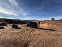
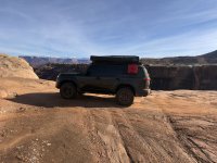
- In my opinion, the west side is more visually appealing due to driving along the Green River and Soda Springs Basin. The east side is just a drive in the canyon with the most interesting points being Lathrop Canyon and Musselman Arch.
- For those driving clockwise be aware of blind rock ledges that will jolt your vehicle. When in doubt go left of the trail or go real slow so you won't fly off.
- I hope this helps. Have a good journey if you decide to take on the White Rim Trail.
Attachments
Last edited: